
Vermilion Parish looks to have escaped 2013 hurricane season with 32 days remaining
Vermilion Parish looks to have escaped another Atlantic hurricane season even though there are 32 days left in the 2013 season.
The National Hurricane Center and Colorado State University climatologists Philip Klotzbach and William Gray predicted that there would be an above average number of hurricanes and severe hurricanes.
Hurricane season ends in Nov. 30 and the way it looks, Vermilion Parish will be spared a hurricane, based on history.
Dating as far back as the 1950s, the parish has not been hit by a November hurricane. Hurricanes are known to form in the Gulf of Mexico in November.
On November 10, 2009, a hurricane formed and hit the Alabama coast.
On Sept. 10 - the halfway point - often viewed as the most active period - the number of cyclones that have grown big enough to earn names is on track to meet the named-storm predictions. But the number of hurricanes and the number of intense hurricane activity days have lagged well behind, according to forecasters with the National Hurricane Center.
In May, NOAA’s Climate Prediction Center predicted a 70-percent chance of there being 13 to 19 named storms, 6 to 9 of which would be hurricanes, with 3 to 5 of those being major, with sustained winds greater than 111 mph. The hurricane season runs from June 1 to November 30.
To date, there have been only nine named storms, of which two were minor hurricanes, said Dennis Feltgen, a meteorologist and spokesman for the National Hurricane Center. More significantly, the “Accumulated Cyclone Energy” index, which measures the power of hurricanes during the hours they are active, is well below the historical average.
Klotzbach said the storm intensity has measured only between 30 percent and 40 percent of normal for Atlantic hurricane seasons. And he said that in the eastern and northern Pacific Ocean, both the accumulated energy index and the number of tropical cyclones -- which includes depressions, tropical storms and hurricanes, or in the Pacific, cyclones -- also is below normal. To have quiet seasons in all three cyclone basins is very unusual, he said.
Adding to that unusual pattern in the Atlantic are sea surface temperature readings that remain above average. Higher sea surface temperatures are one of the factors often associated with more active seasons, Klotzbach said.
But Feltgen warned against thinking that this year’s Atlantic hurricane season is over.
“Think of the season as having just passed halftime,” he said. “A lot can happen in the second half, and be very different than the first half.”
Louisiana State Climatologist Barry Keim was a bit more limiting in his prediction for the chance of storms hitting the northern Gulf of Mexico coast, including Louisiana, during the rest of the season.
“The window of opportunity for a severe hurricane probably exists only during the next two or three weeks,” Keim said. “By mid-October, the chance of a hurricane in the Gulf is very low, and the chance beyond the end of October is pretty nil. We’ve never had a landfalling hurricane in Louisiana in the month of November.”
Only Hurricane Ida, whose outer winds cut across the mouth of the Mississippi River on Nov. 9, 2009, before crossing Mobile Bay the next day, has come close.
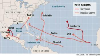
The 2013 season almost set a record that would mark its relative inactivity, when Humberto became the first hurricane of the season at 4 a.m. Central time on Sept. 11.
“In the satellite era, with continuous coverage of the entire Atlantic basin available via the GOES satellites beginning in 1967, Humberto ranks second for the latest first hurricane formation of the season,” Feltgen said.
Including the pre-satellite era, Humberto was the seventh latest, with the all-time first-hurricane record held by a hurricane that formed on Oct. 8, 1905.
Keim pointed out that Humberto also was the latest name in the alphabet for a first hurricane.
Keim said two seasons list no hurricanes, 1907 and 1914. But the pre-satellite record may not be accurate, because a hurricane may have formed somewhere in the Atlantic before the recorded storms, but have not been observed and recorded.
But as a reminder of how it may still be too early to call this season a dud, Feltgen points out that the latest a hurricane has formed in modern times was in 2002, when Gustav was declared a hurricane at 7 a.m. Central time on Sept. 11. (That Gustav is not to be confused with the 2008 hurricane that hit New Orleans.)
In 2002, Gustav was followed by Hurricane Isidore, which crossed the Yucatan Peninsula as a Category 3 storm, but weakened to a tropical storm and then a depression as it hit Grand Isle on Sept. 26, dropping 15.97 inches of rain in Metairie.
Following close behind Isidore was Hurricane Lili, which reached Category 4 strength just 12 hours before making landfall near Lake Charles as a Category 1 storm. Wind gusts of 120 mph were measured in Louisiana, however, and the storm caused more than $1 billion in damages in 2013 dollars, and left 237,000 people without power.
So what’s blocking the formation of hurricanes this year?
Feltgen said center forecasters blame an unusual weather pattern where dry, stable air, sometimes accompanied by dust from the Sahara region of Africa, has been sinking in the central and eastern tropical Atlantic Ocean.
The thunderstorms that make up a tropical cyclone are formed when moist air is rising, so the sinking air is believed to be suppressing development.
- Log in to post comments